

I've been having dreams about being lost lately. This started before Thanksgiving. Yes, I am in a new place, adjusting and adapting as I go along. But I know where I am. I am in Ukraine, in the town of Starobilsk, in eastern Lugansk Oblast, near the Russian border.
I was explaining this to my sister Andy, telling her about my dreams. Sure I get lost sometimes. I take a wrong turn, get on the wrong bus, miss cues because of the language, misread signs, misread directions, misplace things. Andy laughs. She reminds me that this is nothing new. "We all know this about you, Fran, and love you anyway!"
Well, that's comforting. So I brought myself to a new place and my old self is up to its old tricks! It's a sobering realization.
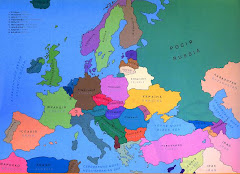
Let's stick to geography, shall we? You can see where I am by looking at these maps. I can see where I am, too.
That's what's so nice about maps. They locate you. They show the way. And they are beautiful. They contain lots of useful information in a small space. They can show everything from terrain to weather patterns to highways, roads, and streets. They give you a sense of direction and distance. They fascinate and beckon.
Ukraine is about the size of Texas. It looks a lot like Nebraska, Ohio and the midwestern states. Farmland, rich black soil, and amber waves of grain predominate. Ukraine is the famous historical "breadbasket of Europe."
It has many rivers, the largest being the Dniper, which divides the country in two, East and West. This geographic divide is also a cultural divide, for reasons going back hundreds of years. When our group of fifty was told we would be studying Russian, we knew that we would be going East for our Peace Corps site, while the Ukrainian language group would be going West.
Ukraine's southern border is washed by the Azov and the Black Sea, which connects to the Mediterranean Sea through Turkey. Crimea, an autonomous republic of Ukraine, has a large Tartar population that is returning home after being exiled by Stalin in the 1930s.
The southeastern part of Ukraine is industrialized. Heavy machinery, mining and other industries mar the landscape and pollute the environment. Towns were thrown up topsy turvey to house workers, those ugly Soviet-style apartment buildings.
Of course the worst case of environmental disaster recently was the explosion of the atomic plant at Chernobyl, up North, not far from Chernigov. Radiation spewed forth over the land for miles and miles. Radiation levels are now, supposedly, at relatively safe levels, but, sadly, the effects on children, adults and newborns are still being felt.
Ukraine's time zone is 2 hours ahead of London, 7 hours ahead of New York City (and St. Petersburg and Toledo), and 10 hours ahead of Los Angeles. When I wake at 8:00 am, it's 1:00 am in Toledo. If I could be up at 3:00 am, it's the best time to call my kids, because it's 8:00 pm there. I did that once. Woke up at 3:00 am, went outside into the garden with my cel phone (it was a starry moon-lit night), and had a great talk with Alli and Josh and their mom.
There are 5 cities with over one million people or more: Kiev, the capital and the ancient birthplace of Russia and Ukraine; Khargiv, Donetsk, Dnipropetrosk, and Odessa. Western Ukraine is more densely populated than eastern Ukraine, but its largest city, Lviv, has only 790,000 people. It's a beautiful city with a fascinating history, once controlled by Poland.
Ukraine, near the 45th parallel, has four seasons; it's pretty much the same in every part of the country, with minor variations in Crimea and the Carpathian mountains in the west. When I tell Jud the days are colder and shorter, and we haven't seen the sun for days, he says yep, same in Konotop, which is way up North. Suzanne, outside of Lviv, says winter is coming there, too. Same in Odessa, say Ilsa and Carl.
Distances afterall are not that great. It's not like the distance beween Toledo, Ohio, and Saint Petersburg, Florida, or for that matter between Tallahassee and Miami, Florida. I think it's mostly the transportation system in Ukraine that makes it feel like that. For instance, it takes me two hours to get to Lugansk by bus, and another 17 hours to get to Kiev by train. The roads are bad and there's not a reliable inter-oblast system, but if you can go by car, you can cut those times considerably. A modern highway system would do wonders to cut distances even further.
So, this is my physical environment. I do not feel lost. I have my maps. Do I know where I am? You betcha! And I can see Russia from here, too.


No comments:
Post a Comment